Union Pier: Mobility Nexus through the Centuries
 Processing Request

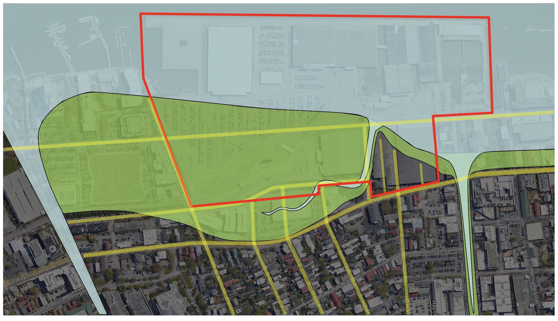
The site known as Union Pier has been a transportation crossroads for centuries past and might continue as such well into the future. Now slated for redevelopment, the seventy-acre industrial complex on the Cooper River waterfront includes the vestiges of historic trails used by earlier generations to facilitate access between land and water via streets, alleys, ferries, streetcars, and freight trains. In this episode, we’ll review the accretion and deletion of various pathways and consider their cumulative role in shaping the future landscape.
Today’s program springs from a conversation with our neighbors at Charleston Moves, a non-profit organization advocating for safe and equitable transportation options in our community. Like many residents, they’re concerned about the future of public mobility across the waterfront property owned, until very recently, by the South Carolina State Ports Authority. Developers, politicians, and residents alike are currently debating plans for the future of what appears on modern maps like an asphalt monolith projecting into the Cooper River, bounded to the west by Washington and East Bay Streets, to the north by Laurens Street, and extending southward nearly to the east end of Cumberland Street. A few roadways traverse this stark landscape at present, but public movement through the site is generally impeded by the vestiges of its industrial past. With redevelopment on the drawing board, everything about the future character of Union Pier is subject to debate.
Local advocacy groups like the Preservation Society of Charleston and the Historic Charleston Foundation have stoked public engagement with plans for the rebirth of Union Pier, and helped the community digest the complicated, sprawling history of the seventy-acre site. Rather than duplicate their commendable work, I’d like to share my responses to recent questions about the transportation history of the landscape now called Union Pier that might help us envision future mobility to and through the site.

Has Union Pier always been such a large, monolithic landscape?
No, most of the area in question was either tidal marshland or completely underwater until the middle of the nineteenth century, and was controlled by a number of private parties until a series of consolidation campaigns around the turn of the twentieth century reduced the number of owners. From a historical perspective, we can think about the Union Pier site as a landscape divided into three parts of roughly equal size. The southernmost part, south of Pritchard Street, was surveyed in 1672 and became part of the “Grand Model” or urban plan of Charles Town (see Episode No. 245). The middle third of Union Pier represents the waterfront area of a suburban plantation known in the colonial era as Rhettsbury or Rhett’s Point, and later called Trott’s Point (see Episode No. 53). The northernmost third part of the present pier—including the historic facade of Bennett’s Rice Mill—is part of the suburban tract known as Ansonborough that was subdivided in the middle of the eighteenth century (see Episode No. 111). Each of these three geographic divisions had its own distinct history of use and development for many generations before they were bundled together into the present Union Pier.
Which of these three divisions played the greatest role in the site’s early history?
The southernmost third of the present Union Pier hosted far more activity than the more northern parts that were underwater during the early generations of recorded history. Early maps and property records tell us that early settlers recognized the utility of a natural promontory or headland at this waterfront site, roughly triangular in shape, that extended eastward from East Bay Street into the Cooper River. As I described in Episode No. 256, this forgotten feature was known to early Charlestonians as “the Hard” because it represented a firm landing place that was above the tidal fluctuations of the adjacent river. The Hard, also known as Rhett’s Point, developed into a significant maritime center around the turn of the eighteenth century. Watercraft ranging from simple canoes to trans-Atlantic ships accessed the site via an inlet, roughly synonymous with modern Pritchard Street, curving along the northern edge of the Hard. Shipwrights and other tradesmen—both free and enslaved—built, repaired, and serviced vessels of various sizes here. Colonial-era travelers seeking to cross the Cooper River also found ferry boats powered by enslaved oarsmen at the Hard, from which you can trace the shortest route across the water to Hog Island (now Patriots Point) and the town of Mount Pleasant. In short, this triangular headland, encompassing approximately four acres of natural high land, was the epicenter of cultural activity and mobility in the modern landscape of Union Pier well into the early nineteenth century.
How did the early inhabitants of Charleston travel to and from the Hard?
Although the Hard was included in the 1672 “Grand Model” of urban Charles Town, the natural topography of that era limited the ability of early residents to visit the site. A broad creek or inlet from the Cooper River, formerly known as Daniel’s Creek but now called Market Street, formed the northern terminus of East Bay Street, which was colonial Charleston’s principal thoroughfare and the community’s first public wharf (see Episode No. 180). The only route to the Hard, according to the Grand Model, was an unnamed thoroughfare we call Pinckney Street, which was the first public right-of-way in the early history of Union Pier. The town’s early inhabitants, clustered around the east ends of Tradd and Broad Streets, had to either ford the creek under modern Market Street or travel northward along Meeting Street and turn right onto Pinckney Street.

The residents of early Ansonborough, formerly Bowling Green plantation, and their northern neighbors traveled southward to the Hard and onward to urban Charleston by treading along the highest and driest edge of firm land along the Cooper River waterfront. Traffic along this meandering route in the late 1600s and early 1700s created a footpath, six feet wide, across private property lying just outside the northern frontier of urban Charleston. Access to this common route suddenly ceased in the spring of 1728, however, when Nicholas Trott, the new owner of Rhettsbury and the Hard, removed a small footbridge to discourage his neighbors from trespassing across his land. Captain George Anson, Trott’s neighbor directly to the north, filed a complaint that April, and in May the Commissioners of the High Roads for the Parish of St. Philip ruled that common usage over multiple decades had rendered the footpath a public thoroughfare. Anson’s footpath along the high-water mark of the Cooper River is now the curving section of East Bay Street between Laurens and Pinckney Streets.[1]
Similarly, the residents of urban Charleston thanked a trio of investors for streamlining the flow of traffic between the center of town and the Hard. George Hunter, Charles Pinckney, and Thomas Ellery pooled their money in 1736 to purchase a nine-acre tract called Colleton Square or Lot No. 80 of the Grand Model, which included most of Daniel’s Creek and the adjacent high land on the south side of Pinckney Street. While subdividing the buildable acres into smaller residential lots, they built a small wooden bridge across the creek and offered it to the provincial government for general use. In May 1744, the South Carolina General Assembly ratified an act declaring the bridge and a road continuing northward to Pinckney Street, twenty-two feet wide, to be a public thoroughfare forever. This is now the section of East Bay Street between Market Street and Pinckney Street.[2]
The bridge across Daniel’s Creek increased the volume of traffic to and from the Hard and inspired the creation of additional paths from East Bay Street to the maritime site. By the middle of the eighteenth century, the heirs of William Rhett and Nicholas Trott had opened Hard Alley, twelve feet wide, parallel to Pinckney Street and ninety feet north of the older thoroughfare. Thomas Rose opened a similarly parallel path called Rose Alley shortly after his 1763 purchase of a piece of the ground nearly opposite the east end of Guignard Street.[3]
While the proprietors of Colleton Square acquired the low water lots fronting Daniel’s Creek in the late 1730s, they chose to transform that waterway into a public canal. Charles Cotesworth Pinckney and several of his neighbors formally ceded the canal and adjacent wet lands to the City of Charleston in 1788 to create Market Street, one hundred feet wide, extending from Meeting Street to the channel of the Cooper River. Most of that tidal area was filled in the nineteenth century, and the public water landing at the east end of Market Street now forms the part of the southern boundary of modern Union Pier.

How did the streetscape of the present Union Pier expand beyond the Hard?
The natural high ground of the Hard served as the nucleus or staging point from which humans pushed farther to the southward, northward, and eastward, filling tidal marsh lands over successive generations to create the present landscape of asphalt and concrete. These early reclamation endeavors were mostly private enterprises, so it’s difficult to determine exactly when or how the large swath of marsh and river that is now Union Pier was created, but a plat drafted in 1802 of Florian Mey’s wharf just north of Pinckney Street shows how wharves of that era were commonly constructed. Cribworks—that is, log frameworks held in place with pine piles—were submerged into the river and filled with shell or earth to create a hard wharf or landing next to a dock where tall ships could load cargo.[4] The wharves formed the first phases of made-land at sites like Union Pier, and merchants built shops and warehouses on them to service the maritime industry. Over time, silt and debris accreted between the wharves, clogging the docks and prompting wharf owners to build further east into the river. Residents and the city government also used “sweet sweepings,” or garbage and manure, to fill lowlands along the Cooper River.
As land accreted both by human intervention and tidal action, residents began to develop eastward into the Union Pier tract, extending the street grid and creating new thoroughfares to access the new land and to extend their wharves. From the heirs of William Rhett, William Pritchard and his son of the same name purchased in November 1800 a relatively small swath of land immediately north of the Hard. Father and son then created a new street, thirty feet wide and one block long, called Pritchard Street, to facilitate access from East Bay Street to the Cooper River.
Immediately after that achievement, the Pritchards settled an agreement with their neighbors to the south and north to widen Hard Alley to twenty feet and to create a new thoroughfare along the eastern edge of the Hard, parallel to the Cooper River. Concord Street, created in 1801, originally stretched from a point slightly north of Pritchard Street southward to Pinckney Street, a distance of approximately two hundred feet. At that time, the fifty-foot-wide street was underwater at high tide. Its extension further to the south and north depended on two factors: gaining permission from property owners along the projected path, and filling the landscape to raise the ground above the daily tides. Both goals required many decades of work to achieve.
A spirited drive to extend Concord Street northward and southward from its origin adjacent to the Hard followed a profusion of wharf construction along the Cooper River waterfront during the second quarter of the nineteenth century. The labor and expense of filling the former marshland fronting Ansonborough and Rhettsbury, combined with resistance to railroad intrusion, succeeded in retarding the street’s growth, however. At the time of the Civil War, Concord Street stretched from the east end of Market Street to the east end of Hasell Street—a distance of around one thousand feet.

What types of vehicles carried bulk goods to the Cooper River wharves?
Many plantation commodities grown in the surrounding Lowcountry, like rice, sea-island cotton, and corn, traveled along local waterways to reach the nineteenth-century wharves composing the modern site of Union Pier. Antebellum wharf owners constructed ever-larger docks, mills, and warehouses to process and store the goods that dockworkers transferred from the Cooper River waterfront to ocean-going vessels sailing overseas or to the northern states. Barges and steamboats landed at wharves named for the merchants and shipping companies that built them, such as Bennett’s North and South Wharves. The façade of Bennett’s Rice Mill, constructed in the 1840s, stands as the sole reminder of this by-gone era on the present landscape of Union Pier.
Equine-drawn vehicles like wagons and drays also brought bulk goods from the inland countryside to the present pier site via the urban street grid, but their use in the city actually intensified after the advent of steam-powered locomotion. The Palmetto City was at the forefront of railroad technology during the second quarter of the nineteenth century, launching a freight and passenger line in 1831 to the now-defunct town of Hamburg, South Carolina. Steam power was a new and volatile technology at that time, however, qualities that bred prejudice against the industrial innovation. Although merchants and planters lobbied to bring country rail lines through the heart of urban Charleston and directly to the Cooper River waterfront, residents and some local politicians fought to keep the noisy, sooty steam engines from crossing the city’s northern boundary. After heated debates in the 1830s, City Council decided to restrict rail infringement into the city. For most of the nineteenth century, rail lines terminated at the depots between Meeting, King, John, and Line Streets (now the Charleston Visitor Center and the Music Farm). Bulk goods had to be unloaded from the rail cars and packed onto equine-drawn vehicles for a crosstown journey to the present site of Union Pier to reach the shipping lines necessary for export. The short but obligatory equine conveyance delighted carriage drivers but infuriated planters and merchants who paid inflated costs for shipping goods abroad via the port of Charleston.[5]

Did streetcars or trolleys ever traverse the landscape of Union Pier?
Horse-drawn streetcars operated by the Charleston City Railway Company first appeared in the city in 1866 (see Episode No. 113) and eventually established a route along the length of East Bay Street, but they did not did not penetrate the industrial landscape of the present Union Pier. A rival company called Enterprise Street Railway began operating in 1871 with hopes to compete with the equine-powered drays and overtake the business of transferring freight from the rail depots north of Calhoun Street to the city wharves along the Cooper River waterfront. That street rail freight service did not flourish, however, and was extinguished by the fervent hopes of local capitalists to extend railroads to the wharves via Concord Street.[6] Passenger streetcar service around the periphery of Union Pier was supplanted in 1897 by an electric trolley line, which in turn was replaced by a fleet of diesel buses in 1938 (see Episode No. 114).
When did the railroads enter the landscape of Union Pier?
Railroad enthusiasts revived the drive to extend their tracks south of Calhoun Street after the Civil War, arguing that connecting inland rail lines directly to the Cooper River waterfront via Concord Street was necessary to revive Charleston’s shattered economy. At the same time, changes in maritime technology brought ever-larger ships with deeper drafts into Charleston Harbor, and the historic wharves with their shallow docks proved insufficient. Private wharf owners and merchants struggled with the cost of modernizing their facilities as ships steamed past the Union Pier area or abandoned Charleston for other southern ports with better rail service and modern facilities. In response to these challenges, several local investors partnered with Northern capitalists to create a large firm endowed with sufficient resources to make significant changes.
The East Shore Terminal Company, chartered in 1887, took control of several older wharf facilities clustered around the site of the historic Hard and applied pressure to Charleston’s City Council. After decades of debate, city leaders voted in May 1890 to apply public funds to purchase the necessary right-of-way from several property owners to facilitate the extension of Concord Street. The East Shore company also gained a thirty year franchise to operate a railroad spur leading from the Columbus Street terminal to Southern Wharf (now the Carolina Yacht Club) via the new thoroughfare. The project took several years to accomplish, but fulfilled its goal of increasing the volume of freight traveling to and from the wharves forming the present Union Pier and all of the adjacent wharves.[7]

When did Union Pier become the monolithic industrial tract that we see today?
Union Pier and the adjacent Cooper River waterfront was accessible to Charlestonians by foot, boat, and carriage until the turn of the twentieth century, when modern shipping interests trumped traditional patterns of movement. Shortly after the East Shore Terminal Company was reorganized as the Charleston Terminal Company in 1903, for example, that company illegally blocked public access to Hard Alley and Rose Alley. The city initiated litigation to protest the closure of Hard Alley, but eventually agreed to drop the issue in exchange for a swath of land to widen Pritchard Street to its present breadth. Because neither Thomas Rose nor any of his successors had ever formally conveyed right-of-way through Rose Alley to local authorities, the city was reluctant to protest its closure. Both colonial-era pathways now lie under windowless warehouses erected after World War II.
The City of Charleston created its own Port Utilities Commission in 1921 as a ploy to reverse decades of increasing privatization, and in 1922 spent a fortune to purchase Union Pier and dozens of other wharf facilities along the Cooper River waterfront. That endeavor proved too taxing for municipal authorities, however, and in 1947 the city transferred the bulk of its historic waterfront property to the South Carolina State Ports Authority (created in 1942). Cargo handling in the unified Port of Charleston became more efficient and profitable under the SCSPA’s management, but public access to and mobility across the city’s waterfront landscape declined in proportion with the port’s financial success.
The most significant and memorable change occurred in July 1960. In response to requests from the State Ports Authority, the City of Charleston agreed to surrender its claim to several points of historic public access to waterfront sites along the Cooper River, including the easternmost block of Pinckney Street at the Hard and the east end of Market Street, east of Concord Street. This agreement truncated the most valuable end of one of Charleston’s original streets and terminated a deed of trust established in 1788 by Charles Cotesworth Pinckney and his neighbors. It also obliterated the home of Charleston’s famous “mosquito fleet,” a ramshackle armada of wooden boats that brought fresh fish to the city for at least two centuries.[8]
Looking back at the present landscape known as Union Pier, historically-informed residents might see physical clues to its history that had never before caught their attention. Consider, for example, the fact that the bulk of the inter-modal movement between water and land at this site has always radiated from the site once called the Hard. The story of that important landmark, now obscured by doomed warehouses standing to the south of Pritchard Street, provides a fitting reminder to anyone considering the future of Union Pier. Encompassing approximately four acres of valuable high land, the Hard represents the only part of the present Union Pier that was above high tide before the early years of the nineteenth century. The other 66 acres, representing approximately 94% of the landscape in question, is the product of subsequent generations of human engineering. Tread carefully into the future, my friends!
[1] “Comissioners of the Highways Award & Order for a foot path for George Anson Esqr.,” dated 2 May 1728, in South Carolina Department of Archives and History (hereafter SCDAH), Miscellaneous Records (Interregnum Series), volume F: 83–84. The extension of East Bay Street from Laurens Street northward to Calhoun Street occurred in the 1790s, as part of Christopher Gadsden’s efforts to subdivide his waterfront property.
[2] Act No. 719, “An Act for confirming and establishing a public Street from the North Bounds of Charles Town, to the North End of the Bay of the said Town; and for building a Bridge over the Marsh at the North End of the said Bay, and assessing the Lands and Improvements of the several Persons therein named towards defraying the Expence of the same,” ratified on 29 May 1744, was not included in the published in the nineteenth-century collection of the Statutes at Large of South Carolina, but the engrossed manuscript survives at SCDAH.
[3] See the report of corporation counsel to Charleston City Council in Charleston Evening Post, 30 May 1907, page 6.
[4] Gadsden’s Wharf just to the north of Union was filled in a similar fashion. See Charleston Time Machine episode No. 51 to learn more about the history and growth of Gadsden’s Wharf.
[5] See Christina Rae Butler, Lowcountry and High Tide: The History of Flooding, Land Reclamation, and Drainage (Columbia: University of South Carolina Press, 2020), for more information on the development of the Cooper River waterfront and the debate about rail encroachment in Charleston. For more on drays and equine transportation to the waterfront, see Christina Rae Butler, Charleston Horse Power: Equine Culture in the Palmetto City (Columbia: University of South Carolina Press, 2023).
[6] Note that C. N. Drie’s 1872 Bird’s Eye View of Charleston does not show streetcar lines adjacent to Union Pier, but they are present on Louis Barbot’s 1883 map of Charleston published in the city’s Year Book of that year.
[7] Charleston News and Courier, 7 May 1890, page 8, “The Problem Is Solved.”
[8] Charleston News and Courier, 8 July 1960, page 1-B, “ ‘Mosquito Fleet’ To Lose Landing.”
NEXT: A Hawaiian Band in Charleston, 1901–2
PREVIOUSLY: Surf Bathing at Sullivan's Island In the Early 19th Century
See more from Charleston Time Machine
